Administrative Boundaries USA
Use Flexter to turn XML and JSON into Valuable Insights
- 100% Automation
- 0% Coding
Overview
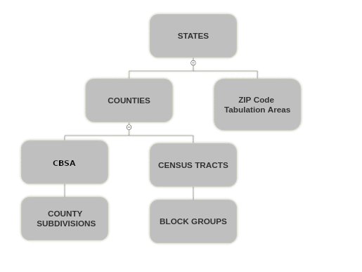
The dataset Administrative Boundaries USA contains border information as polygons about the following divisions of the fifty states, the District of Columbia, Puerto Rico, and the Island areas (American Samoa, the Commonwealth of the Northern Mariana Islands, Guam, and the United States Virgin Islands) of the United States.
- States
- Counties
- Zip Code Tabulation Areas
- County Subdivisions
- Census Tracts
- Block Groups
- CBSA(Core-Based Statistical Area)
Apart from the geographic boundary information as polygons, the data set also includes attributes such as total land area, total water area, FIPS codes and much more. Please refer to the data dictionary further down in this document.
The data set is based on the TIGER/Line Shapefiles from the US Census Bureau. These are extracts of selected geographic and cartographic information from the Census Bureau’s Master Address File (MAF)/Topologically Integrated Geographic Encoding and Referencing (TIGER) Database (MTDB).
Data Sources
The data is based on the census.gov 2020 TIGER Geo Data.
STATE
In the United States, a state is a constituent political entity. Bound together in a political union, each state holds governmental jurisdiction over a separate and defined geographic territory where it shares its sovereignty with the federal government.
COUNTY
Counties and equivalent entities are primary legal divisions of states. In most states, these entities are termed “counties.” Alaska and the Census Bureau cooperatively delineate these census areas for statistical purposes. In four states (Maryland, Missouri, Nevada, and Virginia), there are one or more incorporated places that are independent of any county organization and thus constitute primary divisions of their states. These incorporated places are also known as independent cities. The Census Bureau treats the following entities as equivalents of counties for purposes of data presentation:
| Place | Entity |
|---|---|
| Alaska | Organized Borough |
| Alaska (census areas) | Unorganized Borough |
| District of Columbia | – |
| Louisiana | Parishes |
| Maryland | Independent Cities |
| Missouri | Independent Cities |
| Nevada | Independent Cities |
| Virginia | Independent Cities |
| Puerto Rico | Municipios |
| American Samoa | Districts and Islands |
| Guam | – |
| Commonwealth of Northern Mariana Islands | Municipalities |
| U.S. Virgin Islands | Islands |
Each county or statistically equivalent entity has a 3-character FIPS code that is unique within a state, and an 8-character ANSI code.
The 2020 TIGER/Line Shapefiles reflect available governmental unit boundaries of the counties and equivalent entities as of January 1, 2019.
County Subdivisions
County subdivisions are the primary divisions of counties and their equivalent entities for the reporting of decennial census data (e.g., census county divisions, census subareas, minor civil divisions, and unorganized territories). County subdivisions may represent legal or statistical entities. The data set contains a 5-character FIPS code field for county subdivisions and an 8-character GNIS code.
Census Tracts
Data Source: https://www3.census.gov/geo/tiger/TIGER2020/TRACT/
Census tracts are small, relatively permanent statistical subdivisions of a county or equivalent entity, and are reviewed and updated by local participants prior to each decennial census as part of the Census Bureau’s PSAP. The Census Bureau updates census tracts in situations where no local participant existed or where local or tribal governments declined to participate. The primary purpose of census tracts is to provide a stable set of geographic units for the presentation of decennial census data.
Census tracts generally have a population size of 1,200 to 8,000 people with an optimum size of 4,000 people. The spatial size of census tracts varies widely depending on the density of settlement. Ideally, census tract boundaries remain stable over time to facilitate statistical comparisons from census to census. However, physical changes in street patterns caused by highway construction, new development, and so forth, may require boundary revisions. In addition, significant changes in population may result in splitting or combining census tracts.
Census tract boundaries generally follow visible and identifiable features. Census tract boundaries may follow legal boundaries (e.g., MCD or incorporated place boundaries in some states to allow for census tract-to-governmental unit relationships where the governmental boundaries tend to remain unchanged between censuses). State and county boundaries always are census tract boundaries in the standard census geographic hierarchy.
In a few rare instances, a census tract may consist of noncontiguous areas. These noncontiguous areas may occur where the census tracts are coextensive with all or parts of legal entities that are themselves noncontiguous.
Census Tract Codes and Numbers
Census tract numbers have up to a 4-character basic number and may have an optional 2-character suffix:
For example: 1457.02
The census tract numbers (used as names) eliminate any leading zeros and append a suffix only if required. The 6-digit census tract codes, however, include leading zeros and have an implied decimal point for the suffix. Census tract codes (000100 to 998999) are unique within a county or equivalent area.
The Census Bureau assigned a census tract code of 9900 to represent census tracts delineated to cover large bodies of water. In addition, census tract codes in the 9400s represent American Indian Areas and codes in the 9800s represent special land use areas.
The Census Bureau uses suffixes to help identify census tract changes for comparison purposes. Local participants have an opportunity to review the existing census tracts before each census. If local participants split a census tract, the split parts usually retain the basic number, but receive different suffixes. In a few counties, local participants request major changes to, and renumbering of, the census tracts. Changes to individual census tract boundaries usually do not result in census tract numbering changes.
Relationship to Other Geographic Entities
Within the standard census geographic hierarchy, census tracts never cross state or county boundaries, but may cross the boundaries of county subdivisions, places, urban areas, voting districts, congressional districts, and AIANNH areas.
Census Tract Numbers and Codes:
• 000100 to 939999 – Basic number range for census tracts
• 940000 to 949999 – American Indian Areas
• 950000 to 979999 – Basic number range for census tracts
• 980000 to 989999 – Special land use areas
• 990000 to 990099 – Basic number range for census tracts in water areas 4-24
• 990100 to 998900 – Basic number range for census tracts
Block Groups
Standard block groups are clusters of blocks within the same census tract that have the same first digit of their 4-character census block number (e.g., Blocks 3001, 3002, 3003 to 3999 in census tract 1210.02 belong to block group 3). Current block groups do not always maintain these same block numbers to block group relationships due to boundary and feature changes that occur throughout the decade. For example, block 3001 might move due to a change in the census tract boundary. Even if the block is no longer in block group 3, the block number (3001) will not change. However, the GEOID for that block, identifying block group 3, would remain the same in the attribute information in the TIGER/Line shapefiles because block GEOIDs are always built using the decennial geographic codes.
Block groups delineated for the 2020 Census generally contain 600 to 3,000 people. Local participants delineated most block groups as part of the Census Bureau’s PSAP. The Census Bureau delineated block groups only where a local or tribal government declined to participate or where the Census Bureau could not identify a potential local participant.
A block group usually covers a contiguous area. Each census tract contains one or more block groups and block groups have unique numbers within the census tract. Within the standard census geographic hierarchy, block groups never cross county or census tract boundaries, but may cross the boundaries of county subdivisions, places, urban areas, voting districts, congressional districts, and AIANNH areas.
Block groups have a valid range of zero (0) through nine (9). Block groups beginning with a zero generally are in coastal and Great Lakes water and territorial seas. Rather than extending a census tract boundary into the Great Lakes or out to the 3-mile territorial sea limit, the Census Bureau delineated some census tract boundaries along the shoreline or just offshore.
ZIP Code Tabulation Areas
ZCTAs are approximate area representations of U.S. Postal Service (USPS) 5-digit ZIP Code service areas that the Census Bureau creates using census blocks to present statistical data from censuses and surveys. The Census Bureau defines ZCTAs by allocating each block that contains addresses to a single ZIP Code tabulation area, usually to the ZCTA that reflects the most frequently occurring ZIP Code for the addresses within that block. Blocks that do not contain addresses but that are completely surrounded by a single ZIP Code tabulation area (enclaves) are assigned to the surrounding ZCTA; those surrounded by multiple ZCTAs will be added to a single ZCTA based on the longest shared border. The Census Bureau identifies ZCTAs using a 5-character code that represents the most frequently occurring USPS ZIP Code within that ZCTA. This code may contain leading zeros. Users should not use ZCTAs to identify the official USPS ZIP Code for mail delivery. The USPS makes periodic changes to ZIP Codes to support more efficient mail delivery. ZIP Codes that cover primarily nonresidential or post office box addresses may not have a corresponding ZCTA because the delineation process uses primarily residential addresses, resulting in a bias towards ZIP Codes used for city-style mail delivery.
CBSA(Core-Based Statistical Area)
A core-based statistical area (CBSA) is a U.S.A geographic area defined by the Office of Management and Budget (OMB) that consists of one or more counties (or equivalents) anchored by an urban center of at least 10,000 people plus adjacent counties that are socioeconomically tied to the urban center by commuting. Areas defined on the basis of these standards applied to Census 2000 data were announced by OMB in June 2003. These standards are used to replace the definitions of metropolitan areas that were defined in 1990. The OMB released new standards based on the 2010 Census on July 15, 2015. The term “CBSA” refers collectively to both metropolitan statistical areas and micropolitan areas. Micropolitan areas are based on Census Bureau-defined urban clusters of at least 10,000 and fewer than 50,000 people.
Data Dictionary
TL_2020_US_STATE
| COLUMN_NAME | DATA_TYPE | DESCRIPTION |
|---|---|---|
| REGION | TEXT | Current region code |
| DIVISION | TEXT | Current division code |
| STATEFP | TEXT | Current state FIPS code |
| STATENS | TEXT | ANSI feature code for the state or equivalent entity |
| GEOID | TEXT | State identifier; state FIPS code |
| STUSPS | TEXT | Current United States Postal Service state abbreviation |
| NAME | TEXT | Current state name |
| LSAD | TEXT | Current legal/statistical area description code for state |
| MTFCC | TEXT | MAF/TIGER Feature Class Code (G4000) COMMENT |
| FUNCSTAT | TEXT | Current functional status |
| ALAND | NUMBER | Current land area |
| AWATER | NUMBER | Current water area |
| INTPTLAT | TEXT | Current latitude of the internal point |
| INTPTLON | TEXT | Current longitude of the internal point |
| GEOMETRY | GEOGRAPHY | Geographical Boundaries |
TL_2020_US_COUNTY
| COLUMN_NAME | DATA_TYPE | DESCRIPTION |
|---|---|---|
| STATEFP | TEXT | Current state FIPS code |
| COUNTYFP | TEXT | Current county FIPS code |
| COUNTYNS | TEXT | ANSI feature code for the county or equivalent feature |
| GEOID | TEXT | County identifier; a concatenation of Current state FIPS code and county FIPS code |
| NAME | TEXT | Current county name |
| NAMELSAD | TEXT | Current name and the translated legal/statistical area description for county |
| LSAD | TEXT | Current legal/statistical area description code for county |
| CLASSFP | TEXT | Current FIPS class code |
| MTFCC | TEXT | MAF/TIGER Feature Class Code (G4020) |
| CSAFP | TEXT | Current combined statistical area code |
| CBSAFP | TEXT | Current metropolitan statistical area/micropolitan statistical area code |
| METDIVFP | TEXT | Current metropolitan division code |
| FUNCSTAT | TEXT | Current functional status |
| ALAND | NUMBER | Current land area |
| AWATER | NUMBER | Current water area |
| INTPTLAT | TEXT | Current latitude of the internal point |
| INTPTLON | TEXT | Current longitude of the internal point |
| GEOMETRY | GEOGRAPHY | Geographical Boundaries |
TL_2020_US_COUSUB
| COLUMN_NAME | DATA_TYPE | DESCRIPTION |
|---|---|---|
| STATEFP | TEXT | Current state FIPS code |
| COUNTYFP | TEXT | Current county FIPS code |
| COUSUBFP | TEXT | Current county subdivision FIPS code |
| COUSUBNS | TEXT | ANSI feature code for the county subdivision |
| GEOID | TEXT | County subdivision identifier; a concatenation of current state FIPS code, county FIPS code, and county
subdivision FIPS code |
| NAME | TEXT | Current county subdivision name |
| NAMELSAD | TEXT | Current name and the translated legal/statistical area
description code for county subdivision |
| LSAD | TEXT | Current legal/statistical area description code for county
subdivision |
| CLASSFP | TEXT | Current FIPS class code |
| MTFCC | TEXT | MAF/TIGER Feature Class Code (G4040) |
| CNECTAFP | TEXT | Current combined New England city and town area code |
| NECTAFP | TEXT | Current New England city and town area code |
| NCTADVFP | TEXT | Current New England city and town area division code |
| FUNCSTAT | TEXT | String Current functional status |
| ALAND | NUMBER | Current land area |
| AWATER | NUMBER | Current water area |
| INTPTLAT | TEXT | Current latitude of the internal point |
| INTPTLON | TEXT | Current longitude of the internal point |
| GEOMETRY | GEOGRAPHY | Geographical Boundaries |
TL_2020_US_TRACT
| COLUMN_NAME | DATA_TYPE | DESCRIPTION |
|---|---|---|
| STATEFP | TEXT | Current state FIPS code |
| COUNTYFP | TEXT | Current county FIPS code |
| TRACTCE | TEXT | Current census tract code |
| GEOID | TEXT | Census tract identifier; a concatenation of Current state FIPS code, county FIPS code, and census tract code |
| NAME | TEXT | Current census tract name, this is the census tract code converted to an integer or integer with 2-decimals if the last two characters of the code are not both zeros. |
| NAMELSAD | TEXT | Current translated legal/statistical area description and the census tract name |
| MTFCC | TEXT | MAF/TIGER Feature Class Code (G5020) |
| FUNCSTAT | TEXT | Current functional status |
| ALAND | NUMBER | Current land area |
| AWATER | NUMBER | Current water area |
| INTPTLAT | TEXT | Current latitude of the internal point |
| INTPTLON | TEXT | Current longitude of the internal point |
| GEOMETRY | GEOGRAPHY | Geographical Boundaries |
TL_2020_US_BG
| COLUMN_NAME | DATA_TYPE | DESCRIPTION |
|---|---|---|
| STATEFP | TEXT | Current state FIPS code |
| COUNTYFP | TEXT | Current county FIPS code |
| TRACTCE | TEXT | Current census tract code |
| BLKGRPCE | TEXT | Current block group number |
| GEOID | TEXT | Census block group identifier; a concatenation of the current state FIPS code, county FIPS code, census tract code, and block group number. |
| NAMELSAD | TEXT | Current translated legal/statistical area description and the block group number |
| MTFCC | TEXT | MAF/TIGER Feature Class Code (G5030) |
| FUNCSTAT | TEXT | Current functional status |
| ALAND | NUMBER | Current land area |
| AWATER | NUMBER | Current water area |
| INTPTLAT | TEXT | Current latitude of the internal point |
| INTPTLON | TEXT | Current longitude of the internal point |
| GEOMETRY | GEOGRAPHY | Geographical Boundaries |
TL_2020_US_ZCTA520
| COLUMN_NAME | DATA_TYPE | DESCRIPTION |
|---|---|---|
| ZCTA5CE20 | TEXT | 2020 Census 5-digit ZIP Code Tabulation Area code |
| GEOID20 | TEXT | 2020 Census 5-digit ZIP Code Tabulation Area code |
| CLASSFP20 | TEXT | 2020 Census FIPS 55 class code |
| MTFCC20 | TEXT | MAF/TIGER Feature Class Code (G6350) |
| FUNCSTAT20 | TEXT | 2020 Census functional status |
| ALAND20 | NUMBER | 2020 Census land area |
| AWATER20 | NUMBER | 2020 Census water area |
| INTPTLAT20 | TEXT | 2020 Census latitude of the internal point |
| INTPTLON20 | TEXT | 2020 Census longitude of the internal point |
| GEOMETRY | GEOGRAPHY | Geographical Boundaries |
TL_2020_US_CBSA : Metropolitan Statistical Area/Micropolitan Statistical Area (CBSA)
| COLUMN_NAME | DATA_TYPE | DESCRIPTION |
|---|---|---|
| CSAFP | STRING | Current combined statistical area code, if applicable |
| CBSAFP | STRING | Current metropolitan statistical area/micropolitan statistical area code |
| GEOID | STRING | Metropolitan statistical area/micropolitan statistical area identifier, metropolitan statistical area/micropolitan statistical area code |
| NAME | STRING | Current metropolitan statistical area/micropolitan statistical area name |
| NAMELSAD | STRING | Current name and the translated legal/statistical area description for metropolitan statistical area/micropolitan statistical area |
| LSAD | STRING | Current legal/statistical area description code for metropolitan statistical area/micropolitan statistical area |
| MEMI | STRING | Current metropolitan/micropolitan status indicator |
| MTFCC | STRING | MAF/TIGER feature class code (G3110) |
| ALAND | NUMBER | Current land area |
| AWATER | NUMBER | Current water area |
| INTPTLAT | STRING | Current latitude of the internal point |
| INTPTLON | STRING | Current longitude of the internal point |
| GEOMETRY | GEOGRAPHY | Geographical Boundaries |
Crosswalk table
The crosswalk table holds the hierarchy of the geographic entities as well as can be used to find the parent child relationship among them.
| COLUMN_NAME | DATA_TYPE | DESCRIPTION |
|---|---|---|
| GEOID | TEXT | GEOIDs are numeric codes that uniquely identify all administrative/legal and statistical geographic areas for which the Census Bureau tabulates data |
| NAME | TEXT | Geographic area name |
| GEO_TYPE_CD | TEXT | Geographic area type code |
| GEO_TYPE | TEXT | Geographic area type |
| HIERARCHY_LEVEL | NUMBER | Hierarchy level |
| PARENT1_GEOID | TEXT | GEOID of parent 1 entity |
| PARENT1_NAME | TEXT | Name of parent 1 entity |
| PARENT2_GEOID | TEXT | GEOID of parent 2 entity(present only for a few ZCTAs when it crosses the boundary of more than one state) |
| PARENT2_NAME | TEXT | GEOID of parent 2 entity(present only for a few ZCTAs when it crosses the boundary of more than one state) |
| PARENT3_GEOID | TEXT | GEOID of parent 3 entity(present only for a few ZCTAs when it crosses the boundary of more than one state) |
| PARENT3_NAME | TEXT | Name of parent 3 entity(present only for a few ZCTAs when it crosses the boundary of more than one state) |
| PARENT4_GEOID | TEXT | GEOID of parent 4 entity(present only for a few ZCTAs when it crosses the boundary of more than one state) |
| PARENT4_NAME | TEXT | Name of parent 4 entity(present only for a few ZCTAs when it crosses the boundary of more than one state) |
Usage
Get land area, water area and geographic boundaries of all US states
|
1 2 3 4 5 6 7 8 9 |
SELECT STATEFP, GEOID, NAME, ALAND, AWATER, GEOMETRY FROM TL_2020_US_STATE; |

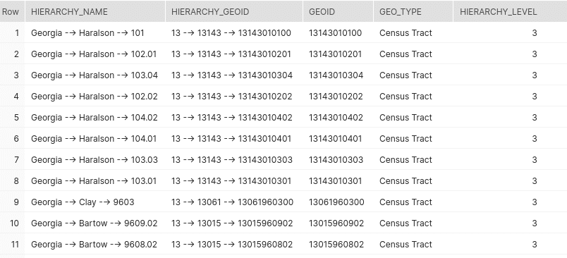
Get the Census tract hierarchy for the state ‘Georgia’
|
1 2 3 4 5 6 7 8 9 10 11 12 13 14 15 16 17 18 19 20 21 22 23 24 25 26 27 28 29 30 |
WITH RECURSIVE CTE1 AS ( SELECT NAME AS HIERARCHY_NAME, GEOID AS HIERARCHY_GEOID, GEOID, GEO_TYPE, HIERARCHY_LEVEL FROM CROSSWALK WHERE GEO_TYPE ILIKE 'STATE' AND NAME ILIKE 'GEORGIA' UNION ALL SELECT HIERARCHY_NAME || ' --> ' || CW.NAME AS HIERARCHY_NAME, HIERARCHY_GEOID || ' --> ' || CW.GEOID AS HIERARCHY_GEOID, CW.GEOID, CW.GEO_TYPE, CTE1.HIERARCHY_LEVEL + 1 FROM CROSSWALK CW JOIN CTE1 ON CTE1.GEOID = CW.PARENT1_GEOID AND CW.GEO_TYPE IN ('County','Census Tract') ) SELECT * FROM CTE1 WHERE GEO_TYPE = 'Census Tract'; |
Get the County Subdivision hierarchy for the place ‘Grand Canyon National Park‘
|
1 2 3 4 5 6 7 8 9 10 11 12 13 14 15 16 17 18 19 20 21 22 23 24 25 26 27 28 29 30 31 32 33 34 35 36 37 38 39 40 41 42 43 |
WITH RECURSIVE CTE1 AS ( SELECT NAME AS HIERARCHY_NAME, GEOID AS HIERARCHY_GEOID, GEOID, PARENT1_GEOID, PARENT1_NAME FROM CROSSWALK WHERE GEO_TYPE IN ('County Subdivision') UNION ALL SELECT HIERARCHY_NAME || ' --> ' || CW.NAME AS HIERARCHY_NAME, HIERARCHY_GEOID || ' --> ' || CW.GEOID AS HIERARCHY_GEOID, CTE1.GEOID, CW.PARENT1_GEOID, CW.PARENT1_NAME FROM CROSSWALK CW JOIN CTE1 ON CW.GEOID = CTE1.PARENT1_GEOID AND CW.NAME = CTE1.PARENT1_NAME ) SELECT HIERARCHY_NAME, HIERARCHY_GEOID FROM CTE1 where GEOID IN -- Get the GEOID of the County Subdivision of Grand Canyon ( SELECT GEOID FROM TL_2020_US_COUSUB CS WHERE ST_CONTAINS(GEOMETRY, TO_GEOGRAPHY('POINT(-113.125092 36.056595)')) ) AND PARENT1_GEOID IS NULL; |

We are offering various GEO datasets. You can find our offering here:


